


Eastern Sierra Air Quality September 25: Still Lousy from Forest Fires
Related: air quality, Eastern Sierra, forest fire, health, peak bagging
re: Eastern Sierra Air Quality, September 27
I’ve had to hang out in the Nevada desert while I watch the smoke situation over in the Eastern Sierra from afar. Yesterday was viable for the Sierra , but the drab haze was not appealing for enjoyment or photography and still a modest health hazard, so I’ve just been processing and publishing the stuff I’ve already shot.
Smoke is surrounding me on almost all sides this morning, and I wonder where the heck I’ll go if it gets bad—pondering a “f*ck it” and head home if this persists. The Eastern Sierra is blotted-out or nearly so by the thick haze, and the mountains towards Lee Vining are now invisible to me.
It’s a damn shame, because the weather has been as beautiful as anyone could ask for.
PurpleAir.com air quality maps for PM2.5 and PM10 are as good as far as they go—not very far over here—they can be highly misleading at times due to stratification of the air layers, which can leave the air good in the valley, even as the smoke is much worse higher up. But eyes don’t lie when it comes to haze/smoke. There are few or no air quality sensors at altitude along most of the Eastern Sierra for PurpleAir.com, excepting one at Virginia Lakes (north of Mono Lake), which is not very helpful.
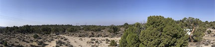
Lee Vining CA roughly where distant power poles are, June Lake and Mammoth Lakes area towards left
iPhone 7 Plus + iPhone 7 Plus 6.6 mm f/2.8 @ 6.6mm ENV: altitude 7376 ft / 2248 m
[low-res image for bot]