


Smoke Plume over Mt Gibbs (Walker Fire)
Related: air quality, Eastern Sierra, forest fire, health, Mt Dana area, peak bagging, Yosemite
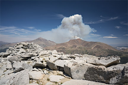
By chance, my daughter and I summitted* Mammoth Peak** with an excellent but smoke free view of what had been only a few hundred acre blaze at 7:30 AM near Lee Vining, CA (happened to be down there and see the relatively small smoke plume).
By mid-afternoon, the smoke plume from the Walker Fire became very impressive, as can be seen. The white cumulus cloud over the plume is presumably caused by precipitation of water vapor onto small but cooled smoke particles.
Mt Dana is seen at left to give a sense of the awesome scale of the smoke plume, which we saw develop over some hours as we summitted and then descended. We watched helicopters and planes and a fat-bellied water tanker head to the fire and back multiple times. Apparently most of the fire fighting gear is still battling the blaze near Clear Lake. The cause is under investigation, but given the absence of any lightning, my guess is that a hunter started the fire (bow season started on Aug 14).
* The hard way. I had not pre-researched the route, and we took a longer and more difficult route from Hwy 120 from the northwest, rathger than the usual route from the Mono Pass trailhead. the summit area has very large slabby and jumbled granite blocks, preceded by loose granitic soil, at least from the “hard way”.
** Mammoth Peak is the most prominent summit seen across Tioga Lake and often has beautiful sunset lighting. It also makes a nice image from Hwy 120 within the park. See also Koip Peak and Kuna Peak.
Sony A7R II + Zeiss Batis 25mm f/2
[low-res image for bot]
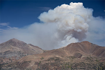
It was an awesome sight. Earlier it had an eerie mushroom-like shape reminiscent of a nuke.
The summit of Mt Dana stayed clear (remained visible). Climbers to that summit must have had a heck of a view.
Sony A7R II + Sony FE 55mm f/1.8
[low-res image for bot]
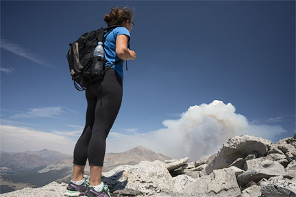
Our campsite in Junction Campground very near far left and bottom had us guessing as to whether we would have to head home early, and even whether our gear might be stranded. Fortunately we were able to return to our campsite, though Hwy 120 east to Lee Vining was closed soon thereafter to traffic at the east Yosemite entrance station (we were discouraged from exiting, but they let us out about 16:30 to our relief). We watched heavy equipment on flatbeds roll by and more the next morning. As of 17:15 on 16 Aug 2015:
One camp host had a real shock, saying “everything I have is down there”. No word on whether it survived, and my empathy goes out to him.
As it turned out the westerly wind kept the smoke at bay from the Ellery Lake / Tioga Lake area even until morning, when we left, and the fire appeared extinguished (no more plume visible, just an ugly haze, though apparently the fire still burns).
Sony A7R II + Zeiss Batis 25mm f/2
[low-res image for bot]
My daughter took this image. I like it because the contrail makes it look as if an incoming missile exploded, generating a huge plume of smoke. There is an ominous feeling to it, as if one is in danger of being over-run by the cloud, or that a shock wave is coming, a feeling complemented by the natural forest foreground.
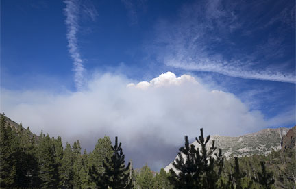
Ricoh GR + 18.3 mm f/2.8 @ 18.3mm
[low-res image for bot]
Conditions
Smoke in the Tenaya Lake area the morning of 16 August was unpleasant, though this smoke appears to be from another smaller fire within the park.
Hwy 120 is affected from the Walker Fire.
Expect delays on, or closure of, Highway 120 east of Tioga Pass due to a fire
Highway 120 east of Tioga Pass is closed due to a fire, however limited convoys are available as fire activity allows. Yosemite National Park, including the Tioga Road inside the park, is open. All other park entrances are open.SR 120 [IN THE CENTRAL CALIFORNIA AREA & SIERRA NEVADA]
IS CLOSED FROM 12 MI WEST OF THE JCT OF US 395 AT EAST YOSEMITE NATIONAL PARK BOUNDARY TO 1 MI WEST OF THE JCT OF US 395 / TIOGA PASS (TUOLUMNE, MONO CO) - DUE TO A WILDFIRE - MOTORISTS ARE ADVISED TO
USE AN ALTERNATE ROUTE
Unrelated note on plague at Yosemite:
Campers with pets are taking a chance with plague. Lots of people had dogs in our campground. Bad idea.
Tuolumne Meadows Campground closed from noon on August 17 to noon on August 21
As an extremely precautionary public health measure, flea treatment will be applied to rodent burrows in Tuolumne Meadows Campground because several dead animals were tested and found to be carrying plague. More »